This website requires certain cookies to work and uses other cookies to help you have the best experience. By visiting this website, certain cookies have already been set, which you may delete and block. By closing this message or continuing to use our site, you agree to the use of cookies. Visit our updated privacy and cookie policy to learn more.
This Website Uses Cookies
By closing this message or continuing to use our site, you agree to our cookie policy. Learn More
This website requires certain cookies to work and uses other cookies to help you have the best experience. By visiting this website, certain cookies have already been set, which you may delete and block. By closing this message or continuing to use our site, you agree to the use of cookies. Visit our updated privacy and cookie policy to learn more.
Point of Begining Logo
search
cart
  • Sign Out
  • My Account
Point of Begining Logo
  • Magazine
    • Current Issue
    • Digital Edition
    • Classifieds
    • POB eNewsletter
  • Columns
    • GeoDataPoint Blog
    • Kline: Unmistakable Marks
    • Lucas: Traversing the Law
    • Solo Notes
    • Editor's Points
    • Turner: Surveyor's Footsteps
    • The Business Side
  • News
  • Products
  • Tech
    • GeoDataPoint
    • LiDAR/Laser Scanning/3D
    • Photogrammetry
    • GIS
    • GPS/GNSS
    • Hardware
    • UAS/UAV
    • Data Collection
    • Remote Sensing
    • Software
    • Total Stations
  • Industry
    • Aerial
    • BIM
    • Boundary & Topo
    • Construction
    • Energy & Utilities
    • Environmental
    • Forensics
    • Government
    • Marine/Hydrography
    • Mining
    • Transportation
  • Reports
    • Laser Scanning & 3D
    • Salary & Benefits
    • Surveying & Mapping Industry Software
    • Archives & Additional Reports
  • Education
    • Professional Knowledge
    • Continuing Education
    • GeoLearn
  • Online
    • Events
    • Webinars
    • Classifieds
    • POB Store
    • POB Point and Shoot
    • Photo Galleries
    • Videos
    • Polls
    • FARO Webinars
    • Industry Links
  • Directory
    • GeoLocator
  • Contact
    • Editorial Staff
    • Advertise
    • Store
  • POB Premium
Home » Calculating Traverses is Easier Using the Azimuth Trick
Surveying Basics

Calculating Traverses is Easier Using the Azimuth Trick

calculating a traverse using azimuths - Figure 3
June 25, 2019
Harold Schuch
KEYWORDS Angle measurement / fundamental principles of land surveying / high precision surveying
No Comments

Calculating the traverse that represents a parcel can benefit significantly from something that is not properly taught: The use of azimuths.

What is an azimuth? It is a horizontal angle of a line, with the zero at astronomic north, and measured clockwise. It can range from 0 to 360 degrees. Figure 1 shows that line AB has an astronomic direction of AzAB.

Those familiar with bearings will agree that the continuous handling of bearings in calculations is a pain. If all necessary bearings of a traverse are first converted to decimal azimuths, calculations become much easier.

calculating a traverse using azimuths - Figure 1
Figure 1

Let’s assume that line AB in Figure 1 has a bearing of N 60° 50’23” E. This converts to an azimuth of (60 + 50/60 + 23/3600) = °. I like to use six digits for all angles. If I now have another traverse leg to a point C (as shown in Figure 2), and I measured an angle of, say, 70° 00’00” (or °), what would be the azimuth of line BC? It is the azimuth of line AB, plus 180° (to get the direction opposite to line AB, or direction BA), minus the measured angle at B: AzBC = AzAB + 180° - ° = ° + 180° - ° = °.

calculating a traverse using azimuths - Figure 2
Figure 2

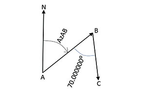
So, that is the azimuth of line BC. Let’s now add the north arrow at point B and draw the azimuth angle for line BC (see Figure 3). This shows that the azimuth of a line shows as much directionality as a bearing does. And, operations with Decimal-Degree (DD) format azimuths are much faster than with Degree-Minutes-Seconds (DMS) format bearings. In addition, the calculations and adjustments of closed traverses are more direct.

calculating a traverse using azimuths - Figure 3
Figure 3

There are two things that need to be heeded. We come out of high school with the idea that a zero direction is along the X (east) axis, while azimuths have the zero direction along the Y (north) axis. This switches the trigonometry, as follows. Look at Figure 4, where I isolated line BC of the traverse. The departure (west-to-east) and latitude (south-to-north) components of line BC are shown as dashed lines and have the following values (using horizontal distance d): Departure = d*sin (AzBC) and Latitude = d*cos (AzBC). This goes contrary to high school trig because the sine is supposed to go up-and-down, not left-and-right. However, if we set the distance d = 500.00’, and calculate the latitude and departure values, the benefits of azimuths become apparent: Departure = 500.00’ x sin(°) = 79.60’ and Latitude = 500.00 x cos(°) = -493.62’. The negative value for the latitude tells us that we are going more south than north.

calculating a traverse using azimuths - Figure 4
Figure 4

One of my favorite tools for calculations is Microsoft Excel, if I remember that it does not accept angle input in DMS format, but only in radians. Therefore, in Excel, the following formulae must be entered: Departure = 500.00’ * sin(radians(°)) and Latitude = 500.00 * cos(radians(°)). If one wants to convert radians back to angles, one uses the degrees function, like alpha = degrees (angle in radians).

Then, adjusting a closed traverse simply becomes a matter of adding up all those positive and negative departures to get a departure misclosure, adjusting departures, and calculating easting coordinates. This is repeated for latitudes and northing coordinates.

With this, I hope to have illustrated that geodesy is much more than just projections.

Recent Articles by Harold Schuch

Positional Accuracy Depends on Measuring Seconds

Defining Geodesy's Role in Geospatial Professions

Pob0319_geodesy01_bbb_900
Harold Schuch is owner and principal consultant for GeoCounsel. He holds a B.Sc in Geodetic Sciences from Ryerson University, Toronto, an M.Sc. in Civil Engineering, Photogrammetry and Remote Sensing from the University of Washington, and a Ph.D. (Cand.) in Civil Engineering, Hydrology from Colorado State University. He is an active PE (civil), a lecturer in “Engineering Surveying” in the Department of Civil Engineering, University of Colorado, and holds an FAA 333 UAV Exemption and Part 107 Remote Pilot license.

Related Articles

Defining Geodesy's Role in Geospatial Professions

Positional Accuracy Depends on Measuring Seconds

Web Exclusive: Calculating the Direction of a Line using Azimuths

Traversing the Law: The Unauthorized Practice of Surveying

You must login or register in order to post a comment.

Report Abusive Comment

Subscription Center
  • Free eNewsletters
  • Customer Care

More Videos

Popular Stories

LiDARUSGS6Nov19POBnews

New USGS LiDAR Base Specification Released

groundpenetratingradarnews23Oct19

GSSI Announces Ground Penetrating Radar Product Line

FAAlogo21Aug19News

Iris Automation and Kansas DOT BVLOS Drone Flight

StantecSolar0Oct19news

Stantec to Provide Design Services for Solar Project

InphoAckerman6Nov19POBnews

Photogrammetry Pioneer Turns 90

Poll

Surveyor Outreach Opportunities

What kind of community outreach do you perform on behalf of the survey/geospatial profession?
View Results Poll Archive

Products

POB Top 100 Report

POB Top 100 Report

We began by creating a survey as a cooperative effort between several high level geospatial leaders, POB staff, and Clear Seas Research market research experts. The survey was sent out to more than 25,000 geospatial professionals who subscribe to POB and/or are members of MAPPS.
See More Products

FARO webinar series

POB

POB November 2019 cover

2019 November

In the November 2019 issue of POB, learn how geospatial professionals in Sweden blended technologies and software to cut costs and increase safety in updating roadside bus stops. Also in this issue, find out how auto manufacturers are addressing challenges with LiDAR in autonomous vehicles.

View More Subscribe
  • Resources
    • Construction Group
    • Associations & Industry Links
    • Editorial Calendar
    • Editorial Guidelines
    • Want More
    • Connect
    • Privacy Policy
  • Advertise With Us
    • Advertise
  • Contact Us
    • Free eNewsletters
    • Customer Care

Copyright ©2019. All Rights Reserved BNP Media.

Design, CMS, Hosting & Web Development ::